
By KHT Staff
TAIPEI — The forecast track for Typhoon Saudel (沙德爾颱風) has moved north, and its gale-force wind radius may remain offshore, the United Daily News reported Tuesday, citing WeatherRisk meteorologist Wu Sheng-yu (吳聖宇).
Wu said a sea typhoon warning was still likely. He said northern Taiwan could face stronger wind and rain if the center passes close enough for rainbands on the storm’s southern side to move ashore, while a more distant track would keep most of the effects at sea.
In southern Taiwan, by midday Tuesday, Aug. 25, cumulative rainfall exceeded 200 millimeters at monitoring points in Shizi Township (獅子鄉), Pingtung County, and Zuoying District (左營區), Kaohsiung, according to Wu. Rain on the east coast has eased since Monday.
Wu expected rain to continue across central and southern Taiwan through Tuesday evening. He also said heat-driven convection could bring rain to northern and northeastern Taiwan.
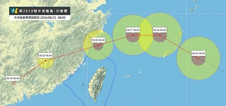
Wu attributed the northward revision partly to Saudel moving farther north than expected near the Ryukyu Islands (琉球群島). He said a retreating Pacific high-pressure system and weaker development of another high-pressure area reduced the forces expected to push the storm south.
Forecast models had remained widely dispersed after the storm passed the Ryukyus, indicating substantial uncertainty, Wu said. Further changes to the track remained possible.
From Wednesday, Aug. 26, stronger vertical wind shear, meaning changes in wind speed or direction with altitude, was expected to make Saudel’s structure more uneven. Wu said the southern side could become stronger than the northern side while the storm’s circulation contracts.
That structure would make the distance between the storm’s center and Taiwan particularly important. Wu said forecasters would need to monitor the angle of any southward turn beginning Wednesday.
Wu also said Typhoons Narra (紫檀颱風) and Atsani (閃電颱風) had been downgraded, leaving Saudel as the only active typhoon in the region at the time of his analysis.
The Central Weather Administration (中央氣象署) updates typhoon analysis and forecasts every six hours. The agency says its forecast range indicates where a storm’s center is likely to move and does not represent the size of its wind field.